
Oyo State, popularly known as the "Pace Setter State", is a cornerstone of economic, cultural, and political history in Nigeria’s South-West geopolitical zone. It is celebrated as a land of firsts, housing the historic administrative foundations of the old Western Region.
Executive Summary & Vital Statistics
- Capital City: Ibadan, which is the third most populous city in Nigeria and famed for its vast expanse of historical brown-roof architecture.
- Current Governor: Seyi Makinde (People's Democratic Party - PDP).
- Date Created: February 3, 1976 (carved out of the old Western State, with Osun State later split from it in 1991).
- Landmass: 28,454 square kilometers, making it the 14th largest state by area in Nigeria and the largest in the South-West.
- Estimated Population: Over 8 million inhabitants (the 6th most populous state in Nigeria).
Geography & Geopolitical Sub-Zones
Oyo State shares borders with Kwara State to the north, Osun State to the east, Ogun State to the south, and an international border with the Republic of Benin to the west. The landscape is dominated by hard dome-shaped hills and a vegetation pattern shifting from tropical rainforests in the south to a rich guinea savanna in the north.
The state is culturally and ethnically homogenous, inhabited mostly by the Yoruba people and distinctively organized into 5 major cultural sub-zones:
- Ibadan Zone: Center of administration and urban commerce.
- Oyo Zone: The historic seat of the ancient Oyo Empire.
- Ogbomoso Zone: A powerful commercial gateway town.
- Oke-Ogun Zone: The vast agricultural food basket bordering Benin.
- Ibarapa Zone: Known for undulating topographies and major agrarian settlements.
Governance & Administration
Oyo State is partitioned into 33 Local Government Areas (LGAs) administered from the state capital. [10]
| Senatorial District | Major LGAs Included | Regional Focus |
|---|---|---|
| Oyo South | Ibadan North, Ibadan Northeast, Ibadan Southwest, Ibarapa Central, Ibarapa East | Urban administrative center & Ibarapa zones |
| Oyo Central | Akinyele, Egbeda, Lagelu, Oyo East, Oyo West, Atiba, Afijio | Mix of industrial urban fringes and traditional Oyo centers |
| Oyo North | Saki West, Saki East, Iseyin, Atisbo, Irepo, Olorunsogo | Agrarian and border trade epicenters (Oke-Ogun) |
Economic Hubs & Natural Resources
The economy of Oyo State is built heavily around agriculture and industrial commerce.
- The Food Basket: The state utilizes massive government farm settlements ( Akufo, Ilora, Ipapo, and Sepeteri) to cultivate cash and food crops such as Cocoa, Cashews, Yam, Maize, Palm oil, and Cassava.
- Solid Minerals: Abundant deposits of high-value industrial materials and gemstones, including Clay, Kaolin, Aquamarine, Marble, and Tourmaline.
- Livestock Powerhouse: Vast cattle ranches are sustained in the northern corridors, predominantly in Saki and Fasola.
Historical Landmarks & Legacies
Oyo State earned its "Pace Setter" moniker by being home to foundational firsts in Africa and Nigeria:
- University of Ibadan (UI): Established in 1948 as the first university in Nigeria.
- Cocoa House, Ibadan: The first skyscraper built in tropical Africa, constructed from the proceeds of the western region's cocoa export boom.
- NTA Ibadan (formerly WNTV): The first television station in Africa, launching broadcasting in 1959.
- University College Hospital (UCH): The premier teaching hospital in Nigeria.
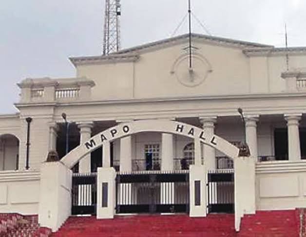
- Natural Tourism: Houses the Old Oyo National Park (historic ruins of the old empire), the Ado-Awaye Suspended Lake (one of only two suspended lakes in the world), and Mapo Hall.